Inspired mathematicians have covered the earth
[with countless hypothetical parallels and meridians.
Because of them we are all, either Indo-Europeans, or Chinese,
[or Filipinos, or Indians,
do to them for our entire life we are accompanied
[by two such lines,
(Latitude-Longitude) to the great joy of the "Big Brother",
[who, on the basis of these lines, makes destines ....
The lands to the East would belong to Portugal,
[and the lands to the West to Castile, in the year 1493 the Pope decided,
Pope Alexander VI* * who issued the edict (Papal Bull)"Inter caetera" *Rodrigo Borgia
[and so, in a way, the world in the two was subdivided.
People at that time did not know the meridians (longitude)
[to determine the border line .....
so the Pope's edict defined the boundary
[a vertical line 100 leagues west Azores, such kind of line.
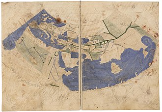
Humanity at that time had not yet realized what the ancient Greeks,
[Eratosthenes, Hipparchus and Ptolemy, did !!
Following the Pope's mandate, Lisbon was displeased,
[but the people were very happy on the Main Square* in Madrid. *Plaza Mayor
___________________________________________________________
* ''IT COULD BE OTHERWISE in verse''
Texts and Narration: Odysseus Heavilayias - ROTTERDAM //
Language adjustments and text adaptation: Kellene G Safis - CHICAGO//
Digital adaptation and text editing: Cathy Rapakoulia Mataraga - PIRAEUS
______________________________________________________________
*A meridian (a line of longitude) a great circle. The notion of longitude was developed by the Greek Eratosthenes (c. 276 BC – c. 195 BC) in Alexandria, and Hipparchus (c. 190 BC – c. 120 BC) in Rhodes, and applied to a large number of cities by the geographer Strabo (64/63 BC – c. 24 AD). But it was Ptolemy (c. AD 90 – c. AD 168) who first used a consistent meridian for a world map in his
Geographia.


No comments:
Post a Comment
Note: Only a member of this blog may post a comment.